FOR the heart of summer I am always looking for good places to walk and La Brena forest is a great place for a cool stroll.
This circular walk gives you the chance to sample the Parque Natural de la Brena and then along the spectacular cliffs which rise 100m above one of the best beaches in Andalucia.
You start by following shady sandy paths towards San Ambrosio, before heading on towards Barbate via a broad forestry track through the stone pines to the cliff path that leads back to Canos past the Torre del Tajo.
This part is the walk’s highlight and I’d recommend building in time for a leisurely picnic (from autumn to spring at least) at one of the viewing points just beyond the tower.
I’ve graded the walk Medium/ Difficult not so much for the distance covered but rather because of the additional effort required when walking on sandy paths.
You could shorten the walk by taking a taxi from Canos to the Punto de Informacion that is to your right as you arrive in Barbate coming from Canos along the A2233.
You’ll see signs here marking the beginning of the cliff path.
The Walk
Distance: 19 kms
Time required: 5 hours
Rating: Medium/Difficult
Total height gain: 225m
Map(s): IGN 1:50000 Barbate 1073 (12-47)
Water: No springs so take plenty
The walk begins outside Hotel Madreselva which you pass as you head east through the village on the A2233. From here head east past a row of palm trees.
Reaching a 3.5T sign turn left.
The road soon arcs left.
Just past the 14km sign, cut left along a sandy track following a sign Sendero Canos-Torre de la Meca.
After running west the road contours right as it passes beneath the Torre de
Meca.
Reaching a three-way junction bear right past a chain that blocks vehicle access.
The track climbs gently as it runs eastwards: views open out above the treetops.
Shortly beyond the top of the rise you pass a sign marking the path up to the Torre de la Meca. (35 mins)
The track runs on due east.
Just before reaching a metal gate and the Majadales del Sol picnic area, cut hard left along a sandy track.
Marker posts lead you on through the forest.
Reaching twin posts, one marked 31 angle right and continue in an easterly direction.
Passing a firebreak the path runs downhill, adopting a northeasterly course, and eventually leads through a green gate (1 hr 10 mins)
beyond which you reach a picnic area.

Angling slightly left you pass a sign Sendero Torre de Meca then, passing stone tables and benches, you reach a tarmac
road.
Cutting left along to the road you cross a cattle grid then after some 650m reach a junction where a sign points left for San Ambrosio.
Ignoring the sign carry on along the track which arcs right, passes a sign prohibiting access to lorries, then reaches a fork. (1 hr 25 mins)
Keep right along the main track (ignoring a sign left for Palomar de la Brena) which you’ll now follow without bifurcating for a little over 2kms.
At first you follow a pylons but these soon angle away to the left.
Reaching a junction by an information board about El Pinar de Pinos Pinoneros (1 hr 45 mins) turn right away from the main track.
Passing a line of animal pens the track runs on through the pines before crossing a cattle grid then reaching the A2233.
Angle right across the road, cross a stile then cut left along a broad sandy track parallel to the road.
After 300m the track angles right.
After 50m you reach a junction. Angle left and continue on parallel to the A2233.
Just as the track angles back toward the road you reach a cattle grid. Here angle 45 degrees to the right then after 75m cut right through the scrub and drop down to the sandy bed of a gulley.
Here cut left and follow a narrow, sandy path down towards the sea.
The gully widens: head on down the easiest path to reach the Barbate-Caños cliff path. (2 hrs 20 mins)

From here head west past a steep cliff face, parallel to the sea: you’ll occasionally see white and green waymarking.
The path leads on past a sign explaining about the Pinares Costeras, or the coastal pine forest: it was planted between 1895-1926 to stabalise the dune system.
200m past the sign you reach the Torre del Tajo. (2 hrs 50 mins)
Be sure to visit the two miradors to its left and right for the finest cliff views of the walk.
Continuing towards Caños you reach a junction where the pole fence that has been to your left comes to an end.
Head straight on. The sandy path now runs slightly further from the sea.
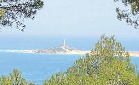
As Cape Trafalgar and its lighthouse come into view the path divides. Take the higher option which leads past a second sign about Pinares Costeros.
Here angle down left then once more right towards Canos and Hotel Mar de Frente.
Passing behind the hotel you reach a signboard describing the path to the Torre del Tajo. Here cut right up a stony track which bears left along the northern edge of the village before descending to the A2233.
Turn left then right to return to the start point of the walk. (3 hrs 45 mins)
Coastal Walks in Andalucia (ISBN 9-788489-954939) by Guy Hunter-Watts, is available at www.books-4spain.com and most local bookshops. It contains a selection of 50 stunning walks close to southern Spain’s Atlantic and Mediterranean coastlines. For more details visit www.guyhunterwatts.com