
SPAIN’S eastern coastline and the Balearics have been placed on high alert as a violent cold front collides with record-breaking Mediterranean sea temperatures to trigger severe storms.
State weather agency AEMET has activated high-risk orange warnings across the Barcelona pre-Pyrenees, the Girona Pyrenees and the northern Alicante coast.
Forecasters warn that more than 40mm of rain could fall in a single hour in these areas on Wednesday morning.
The primary threat to residents and tourists is the high risk of sudden flash floods in normally dry riverbeds, known as ramblas, alongside destructive large hail.
The extreme weather is being fuelled by a Mediterranean Sea that has acted as a massive thermal battery throughout the summer.
AEMET confirmed that sea surface temperatures reached a high of 28.54C on August 13, and even breached 33C at the Sa Dragonera buoy near Mallorca last month.
This super-heated airmass will clash with an incoming Atlantic cold front early on Wednesday morning, driven by a convergence of northerly tramuntana and north-westerly mistral winds.
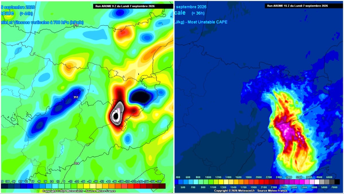
Meteorologist Juanjo Villena noted that the vertical wind models feeding the storm clouds between Tarragona and Barcelona were so extreme they had broken the scale twice over.
The explosive upward convection is expected to trigger torrential downpours exceeding 50mm in a matter of minutes.
The peak danger window for Catalunya is between 5am and 11am on Wednesday, with storms packing large hail, or ‘stones’, capable of damaging vehicles and terrace glass.
Heavy downpours will not be confined to the coastline, with violent storms also forecast to sweep inland across Teruel, eastern Castilla-La Mancha, the Region of Murcia and eastern Andalucia.
As Wednesday progresses, the instability will push south and east towards major expat hubs on the coast and the islands.
Meteored meteorologist Samuel Biener warned that ‘organised convective storm structures’ could form directly over the sea between Catalunya and the Balearics.
These marine storm clusters are forecast to hit Mallorca and Menorca by the afternoon, bringing the threat of local waterspouts and sudden riverbed swells.
The Valencian Community, particularly south of the Gulf of Valencia, will also face severe downpours before the system begins to stabilise on Thursday.
Any lingering showers in the north-east are expected to fizzle out by Thursday, paving the way for a dry, settled weekend across Spain with temperatures returning to seasonal averages.
Click here to read more Weather News from The Olive Press.