THE latest weather models are predicting yet another blast of Saharan air to lick the Iberian peninsula and douse everything in a fine red mist.
A cold front is forecast to blow away the recent balmy temperatures from Wednesday and bring in the fabled ‘blood rain’ to several parts of Spain.
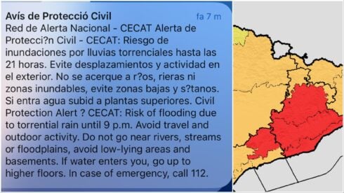
The so-called DANA will form over the west of the country and usher in storms and showers to Catalonia and the northern parts of Spain.
Having already bloodied the Canary Islands, the mud rain is expected to move eastwards across the mainland, where it will bring heavy rain, thunderstorms, and even snow.
The ‘blood rain’ is a phenomenon caused by dust and sand being swept up into the atmosphere by the storm and then deposited on the ground along with the rain.
However, despite being a recognised phenomenon, regular forecasts of Mars-like red skies and rain have so far failed to materialise, leaving Spaniards sceptical.
Whether the colouring comes or not, meteorologists are confident that the DANA will make landfall in Spain on Wednesday and will likely linger through Friday.
The heaviest rain is expected to fall in the northern and western parts of the country, but some rain is also possible in the south and east.
The DANA is also expected to bring a significant drop in temperatures.
After a week of unseasonably warm weather, temperatures are expected to plummet by as much as 10 degrees Celsius in some parts of Spain.
It is still up in the air whether the good weather will return in time for Semana Santa.
READ MORE:
- ‘Blood rain’ latest: These are the 5 best methods for removing the red stains caused by the ‘calima’ –…
- What is ‘blood rain’? All you need to know about Spain’s ‘calima’ weather phenomenon before it blows in from…
- ‘Blood rain’ is coming to Spain: New DANA will bring the weather phenomenon to Andalucia and beyond this week
Click here to read more News from The Olive Press.


