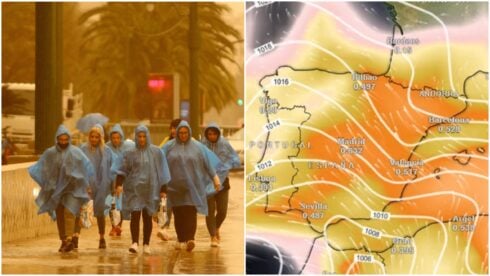
RESIDENTS across Andalucia face a wet and cold start to December as a series of Atlantic storm fronts move in from Tuesday, bringing days of rain, falling temperatures and snow in the mountains.
Forecasts from Spain’s state weather agency Aemet and experts at Meteored indicate that four Atlantic systems will sweep across the country between Tuesday and Saturday, creating what forecasters describe as a ‘storm train’ that will keep conditions unsettled for most of the week.
The unsettled spell follows a showery Sunday across much of the region, with the area around the Strait of Gibraltar placed under a yellow alert for thunderstorms until 8.00pm.
Rain will begin spreading from west to east on Tuesday, with more than 10 litres per square metre expected in the western half of Andalucia.
Aemet predicts very cloudy or overcast skies, light to moderate rain throughout the day, and a snowline dropping from 2,000 metres to around 1,500 metres by nightfall.
Inland temperatures will fall, and strong westerly winds are expected along the Mediterranean coast from midday.
The shift in wind will be felt across the Costa del Sol, where westerlies (‘poniente’) can bring choppy seas, cooler air and heavier localised showers as fronts push through.
Malaga city, Marbella, Estepona, Fuengirola and other expat hotspots should expect a wet day with temperatures dipping several degrees.
On Wednesday, rain is likely again in much of Andalucia, as well as Castilla-La Mancha and Madrid during the first half of the day.
READ MORE: Fury as case is closed in killing of Brit expat in Andalucia tourist town
For the region, Aemet forecasts overcast skies, moderate rainfall and another drop in temperatures, with snow possible from 1,200 metres and light frosts in the eastern sierras.
A third front will arrive from the northwest on Thursday. Meteored maintains the chance of rain above 55% across most of Andalucia, although showers will be less likely along the Mediterranean coast.
Aemet expects cloudy skies and further light to moderate rainfall later in the day.
Conditions heading into the long weekend — the December puente — remain uncertain. Rain risk decreases on Friday, but Aemet still forecasts showers on Saturday, especially until around 6.00pm.
READ MORE: Fresh corruption scandal in Andalucia as high-profile arrests made over Covid-era ‘bribes’
Temperatures may recover slightly as a milder Atlantic air mass arrives from the southwest.
Sierra Nevada is expecting a notable drop in the snowline through midweek, with further snow possible above 1,200 to 1,500 metres, potentially improving conditions for early-season skiers if the precipitation continues.
For now, residents across the coast and inland areas are being advised to prepare for several days of rain, cooler air and strong coastal winds as the first week of December opens under Atlantic influence.
Click here to read more Andalucia News from The Olive Press.