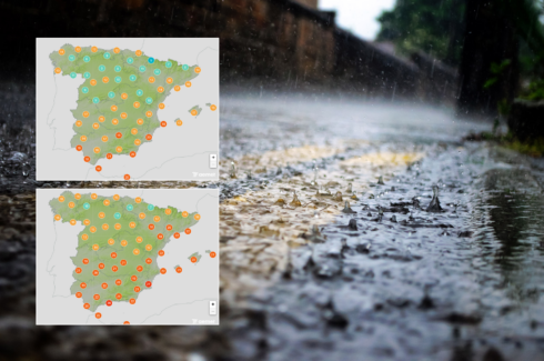
SOUTHERN Spain will sizzle under beach-perfect temperatures today, with thermometers in Malaga and Sevilla set to soar to a sweltering 35C, according to the weather bods at Meteored.
The extreme heat affecting Andalucia comes as part of a weather pattern creating dramatic temperature contrasts across the country, with northern regions experiencing considerably milder conditions.
The Guadalquivir Valley, which includes much of western Andalucia, could see temperatures approaching 34C as the heatwave intensifies.
While sunbathers flock to Costa del Sol beaches to cool off, residents in northern cities are enjoying far more comfortable temperatures.
READ MORE: Spain’s stronghold on British tourism is ‘under threat’ by a Mediterranean rival
Pamplona is forecast to chill in 17C, while Barcelona will only reach 20C.
Bilbao, where around 30,000 Manchester United and Tottenham fans are descending for tonights Europa League final, can expect a mild 19C – still a decent terrace temperature.
Madrid sits on the warm side of these extremes, with the capital forecast a warm 30C.
Health officials remind residents and tourists in southern regions to stay hydrated, limit midday sun exposure, and use appropriate sun protection as these summer-like temperatures continue.
READ MORE: Concern in Spain’s tourism sector as Brits turn their back on holiday islands
Local beach businesses reported increased visitor numbers yesterday as the heatwave drives both locals and tourists to seek relief along the coast.
Meteorologist Nacho Espinos Conejo explains that the rising temperatures ‘remind us that the summer period is just around the corner,’ with the meteorological summer officially beginning in just 11 days on June 1st.
The cause of this sudden temperature spike is the strengthening Azores anticyclone (high-pressure system) moving toward the Iberian Peninsula.
READ MORE: America’s low-cost champion Costco is taking over Spain – and it’s coming to Malaga
This system is expected to bring stable, summer-like conditions throughout most of Spain in the coming days, particularly affecting the central and southwestern regions.
A brief interruption of this pattern is expected Thursday and Friday, when a pocket of cold air could trigger strong thunderstorms along Spain’s eastern Mediterranean coast.
However, the anticyclone will quickly reassert dominance, with stable conditions returning for the weekend.
No precipitation is expected in the short or medium term for central and southern peninsular areas, suggesting this early taste of summer is here to stay.
Click here to read more Weather News from The Olive Press.