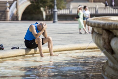
EXPERTS have revealed why rainstorms have battered Spain while the UK suffers a dry spring.
While Spain has experienced the eighth wettest quarter ever recorded, northern europe has rarely seen a shower since February.
According to the European climate change observatory, Copernicus, this is due to the strange behaviour of a high-velocity jet stream responsible for ‘dictating the weather in the region.’
READ MORE: Yellow alerts for heavy rain and hail in popular tourist resorts of Spain
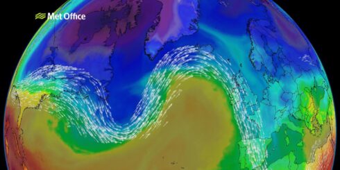
PHOTO: Met Office
The airstream is situated between nine and 16 km above earth and normally carries storms from west to east, creating rain above Ireland, the UK and northern Europe.
It is sandwiched between warm air from the equator and cold air from the north pole, but this year, the jet stream has changed and with it, the region’s weather patterns.
Shaun Harrigan, a scientist from the European Centre for Medium-Range Weather Forecasts, said: “The jet stream has descended and is causing high pressure above Ireland and the UK.”
According to the weather expert, this pushes storms south towards Spain, Portugal and Italy, where pressure is lower.
Satellite images of France provide a stark insight into the issue, with the northern part of the country experiencing very little rain, making it a brown colour, compared to the lush green of south.
The French meteorological agency has stated that the period from February to April has been the driest since 1959.
At the same time, the country experienced its fifth hottest April, measuring 1.7C above average and low rain for the third year running.
“Our forecasts indicate this phenomenon will continue for a few more weeks and it’s hard to say when we’ll return to normality,” he stated.
The situation has not yet reached drought levels, but if heat waves arrive this summer, northern europe could be under threat.

According to Andrea Toreti, coordinator of Copernicus’s Drought Observatory, the situation is ‘very similar’ to 2018, when Germany, Denmark and Sweden were hit by drought.
Meanwhile the UK is experiencing its driest spring in 69 years, with just 56% of expected rain falling in April.
Experts warn that if heavy rain follows, it could lead to flooding across the country similar to those seen in 2012.
English farmers have already started to prepare for the worst by irrigating their fields, while reservoirs are six percent below May 2022 levels.
In Scotland, an ‘early water scarcity risk’ warning has been issued, though experts say this concerns the agricultural sector more than the wider public.
It is also too early to suggest climate change is responsible for changing weather patterns, Harrigan said.
“Research is being done into how climate change could change the jet stream and it’s possible that the north pole is warmer than normal. However, from a scientific point of view, nothing is confirmed.” he added.
Although Toreti also refrained from making a link, he confirmed ‘rain patterns are being affected by climate change’.
He also claimed we are transitioning from a ‘normal’ climate to a ‘warmer’ one, where weather phenomena like those seen this year will become more common.
READ MORE: Spain is slipping into a desert climate, new drought study warns
Click here to read more Spain News from The Olive Press.